Birch Island Conservation Area

Nestled in an elbow of the Weweantic River, Birch Island Conservation Area isn’t actually an island. But with river views peeking through the pines in nearly every direction, you could be forgiven for mistaking it for one. This town-owned conservation area is located next to the Coalition’s Horseshoe Mill, creating a network of trails that are popular with hikers in Wareham.

Features

With soft, hilly trails and glimpses of the Weweantic River at every turn, Birch Island is a place where everyone can enjoy the outdoors. The town of Wareham protected this land in 1972; since then, local outdoor enthusiasts have come to Birch Island to fish in the river and explore the woods.
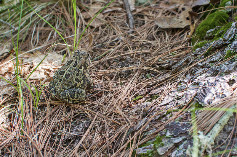
toad at Birch Island Conservation Area

Look low for toads, wildflowers, and other unique sights at Birch Island Conservation Area.

Trails

The main trail at Birch Island Conservation Area loops through the property in a wide circle. Altogether, you can spend an hour or more walking the trails along the river’s edge here and at neighboring Horseshoe Mill. (Download trail map)

Starting at the parking area, follow the trail until you reach the main loop. The trails are blanketed with pine needles in many places, and they climb up and down gently rolling hills. Several smaller trails off to the side lead to fishing spots and scenic river views.

Habitats & Wildlife

The pine forest at Birch Island provides shelter for animals large and small, from rabbits and opossums to white-tailed deer. You can also search the forest for songbirds. Near the edge of the river, look for many species of wintering waterfowl feeding on the Weweantic’s rich fish and plant life.
Property Owned By
Details
Size: 20 acres
Hours: Dawn to dusk
Parking: Medium sized parking area at the end of Station Street
Trail Difficulty: Intermediate
Dogs: Yes (under voice control)
Facilities: None
ADA Accessible: No

Please follow all posted rules and regulations at this property.

Address & Contact Information
Station Street
Wareham, MA 02571
41.766128, -70.749342
Wareham Conservation Commission: (508) 291-3100 x6505

Please follow all posted rules and regulations at this property.

Birch Island Conservation Area
Wareham, MA
View larger map

Related Stories

52 new places to explore around Buzzards Bay in the new year

Set a resolution to discover one of these 52 places each week in the new year. We bet there's many spots on this list you've never explored!

Full Story ›
How (and where) to go geocaching around Buzzards Bay

Looking for a new way to get outside and explore Buzzards Bay’s special places? Try geocaching: a modern-day version of treasure hunting.

Full Story ›
11 day-after-Thanksgiving walks to discover in southeastern Massachusetts

The day after Thanksgiving is a great time to take a walk outside. You can stretch your legs, walk off a big meal, and spend some more quality time with your loved ones.

Full Story ›

Upcoming Events Near Here

Nearby Places To Go

Horseshoe Mill

Discover Buzzards Bay’s largest freshwater river at Horseshoe Mill, part of the growing Weweantic River Reserve in Wareham.

Douglas S. Westgate Conservation Area

If you want to explore a classic Wareham landscape, Westgate Conservation Area is an ideal spot.

Fearing Hill Swamp

Canoe or kayak upstream from Fearing Hill Swamp in Wareham to explore the Weweantic River's protected wooded shores.

Current Issues

Land Conservation

Conserving land is one of the most important ways to protect clean water in Buzzards Bay. Since 1998, the Coalition has forever preserved more than 7,000 acres of land across our region.

Read More ›
NA

Bay Health: Weweantic River – Fresh

Find your water quality score in Bay Health ›