The next time you’re searching for a destination to sail or paddle to, look no further than the Let Conservation Area. This special Westport Land Conservation Trust property is on the East Branch of the Westport River.
Features
The Let Conservation Area – often referred to simply as “The Let” – is unique because it’s only accessible via water. Whether you prefer to paddle, row, or sail here, it’s a great spot to take a break, have a picnic, and explore the property’s network of quiet forested trails. At the landing (marked with a green sign), you can stop to enjoy a beautiful view of Horseneck Channel and the East Branch of the Westport River.
Trails
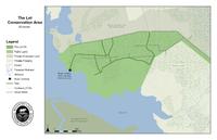
A network of smooth, easy trails weaves through the interior of this 63-acre forested property. Many of the trails end at private property, so please obey all posted signage and respect private property. (Download trail map) Starting from the “trailhead” – the granite knob at the landing – make your way northeast through the woods. You’ll pass under a canopy of trees along these wide trails, a few of which climb up short elevations and cross fieldstone walls. From the highest points, you’ll be able to catch a glimpse south toward East Beach, Buzzards Bay, and even the Elizabeth Islands on a clear day.
Habitats & Wildlife
The Let Conservation Area is mostly coastal forest, with a fringe of salt marshes along the river’s edge. A wide variety of animals make their home here, from juvenile fish and fiddler crabs to ducks, ospreys, and even the occasional bald eagle. At the landing, look for salt marsh bird species like herons and egrets, which stalk the shallows in search of their next meal.
Details & Amenities
Trail Maps
Image Gallery


The next time you’re searching for a destination to sail or paddle to, look no further than the Let Conservation Area. This special Westport Land Conservation Trust property is on the East Branch of the Westport River.
Features
The Let Conservation Area – often referred to simply as “The Let” – is unique because it’s only accessible via water. Whether you prefer to paddle, row, or sail here, it’s a great spot to take a break, have a picnic, and explore the property’s network of quiet forested trails. At the landing (marked with a green sign), you can stop to enjoy a beautiful view of Horseneck Channel and the East Branch of the Westport River.
Trails
A network of smooth, easy trails weaves through the interior of this 63-acre forested property. Many of the trails end at private property, so please obey all posted signage and respect private property. (Download trail map) Starting from the “trailhead” – the granite knob at the landing – make your way northeast through the woods. You’ll pass under a canopy of trees along these wide trails, a few of which climb up short elevations and cross fieldstone walls. From the highest points, you’ll be able to catch a glimpse south toward East Beach, Buzzards Bay, and even the Elizabeth Islands on a clear day.
Habitats & Wildlife
The Let Conservation Area is mostly coastal forest, with a fringe of salt marshes along the river’s edge. A wide variety of animals make their home here, from juvenile fish and fiddler crabs to ducks, ospreys, and even the occasional bald eagle. At the landing, look for salt marsh bird species like herons and egrets, which stalk the shallows in search of their next meal.