Saulnier Memorial Bike Trail
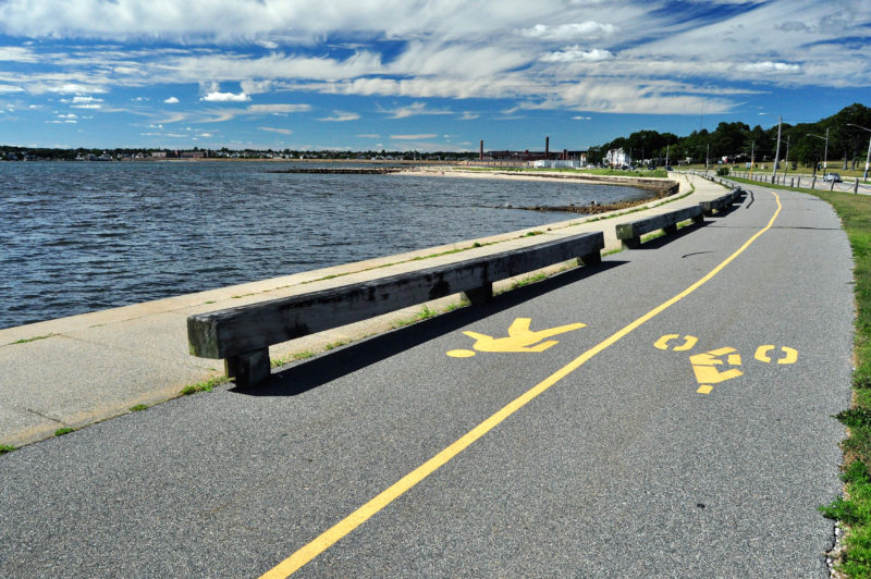
With spectacular open-water views of Clarks Cove, outer New Bedford Harbor, and Buzzards Bay, the Saulnier Memorial Bike Trail is the best route to tour the scenic South End of New Bedford. Bike, walk, jog, or skate along this 3.5-mile city-owned paved waterfront trail while enjoying fresh ocean air, natural beauty, and interesting historical attractions along the way.
Features

The western route of the well-marked Saulnier Memorial Bike Trail runs along Clarks Cove, from West Beach and Hazelwood Park to Fort Taber Park.
Named after Joseph D. Saulnier, a former state representative and New Bedford city councilor, the Saulnier Memorial Bike Trail is a fitting showcase of the best coastal views in the city. The bike trail runs along both sides of New Bedford’s scenic South End peninsula from Clarks Cove to New Bedford Harbor. The paved, well-marked path provides a safe place to walk, bike, run, or skate for all types of outdoor enthusiasts, from avid cyclists to casual walkers and kids learning how to ride. It’s all part of The Blue Lane, a network of pathways that connects neighborhoods along the New Bedford waterfront.
Many other recreational attractions lie along the bike trail, including West Beach and East Beach, historic Fort Taber Park and Hazelwood Park, boat ramps on West Rodney French Boulevard and East Rodney French Boulevard, and the elevated New Bedford Harbor Walk along the hurricane barrier. Bring a picnic lunch, a bathing suit and towel, or even a fishing rod and make a day of your adventure on the bike trail!
Trails
To get started on the Saulnier Memorial Bike Trail, begin at one of three points: Hazelwood Park or West Beach at the western end, Fort Taber Park at the southern tip, or the New Bedford Harbor Walk at the eastern end. From end to end, including the meandering paths through Fort Taber Park and the elevated Harbor Walk route, the bike trail covers about 3.5 miles. (Download trail map)
The west side of the bike trail runs along Clarks Cove, with views of the Dartmouth shoreline. Traveling south, you can either turn left to continue on the bike path along Rodney French Boulevard or stay straight to venture toward Fort Taber Park. We recommend you head into the park, where a sweeping panoramic view of Buzzards Bay opens up in front of you. The bike path traces the tip of Clark’s Point before turning north along outer New Bedford Harbor. On the east side of the bike trail, ride past East Beach to the Harbor Walk, an elevated path atop the New Bedford Hurricane Barrier that provides another fantastic water view.
Habitats & Wildlife
Although the area around the Saulnier Memorial Bike Trail is urban and highly developed, there are plenty of natural habitats and wildlife to explore along the sandy, rocky shores of Clarks Cove and outer New Bedford Harbor. The Clark’s Point peninsula protrudes deeply into Buzzards Bay, making it a wonderful spot for bird watching – particularly in winter, when ducks and geese migrate here from colder northern climates. In spring and summer, the skies are lively with gulls and ospreys diving for fish like herring, sea bass, and bluefish.

 Download Property Map